Introduction to Kahuta of 1947
During British Raj District Rawalpindi was a very prominent place. It had four Tehsils (sub division) i.e. Rawalpindi, Gujjarkhan, Comerry and Kahuta. Kahuta is a mountainous area located 22 miles east of Rawalpindi. For generations Sikh Mahajan have been living here and the other half of the population were Muslims known as Janjua Rajput Do Lal. The total area of Tehsil Kahuta was 950 Square miles and had 550 villages. At the time of partition 26 percent of the population were army pensioners and the collective pension was Rs 125,000 per month. During Maharaja Ranjit Singh’s reign Kahuta was part of Poonch but after his death the British captured Punjab, sold Jammu & Kashmir to Dogras of Poonch and Kahuta was merged with Rawalpindi District.
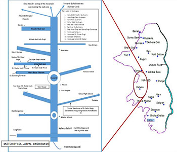
North of Kahuta is Comerry, South is Tehsil Gujjarkhan, West is Rawalpindi and East is River Jhelum. About 22 miles from the East of Kahuta behind Jhelum River is Lakshman Pattan which is in the district of Poonch. From Kahuta there was a road called Galley Wali Gali .There were lots of flowers and fruit trees and on this mountain there was the Devi Temple on top of the mountain. From this temple you could see Kallar Police
station which was about 16 miles from Kahuta. Galley Wali road was in between the two mountains from where the cool breeze of fresh air would flow all year round starting in the night and flowing until 10am with the same speed towards Santas caves (Santa deea gufava) which was only half a mile from the village Batala and then went onto the village Mangla and beyond. Bala, one of the companions of Guru Nanak moved to Dan Gali which was in Tehsil Kahuta where his grave still exists. His descendants still live in Thoa Khalsa in Tehsil Kahuta. Chowdhry Kishan Singh was contracted out to build this road and saw this grave himself.
West of Kahuta was a forestry office which used to be a jail during the Dogra reign. The office of Tehsil was in a small fort, inside of this fort were two big old trees. About a quarter of a mile after passing this office there was a well and a garden built by Barkat Singh Shah and beside it was a beautiful waterfall called Bawa Jattee. There was also a beautiful pond (Bavli) which was built by Choha village tehsildar. Above this was a Thakur Dwara a house for the priest. There was a boundary wall and inside was a large grave of Bawa Jattee, and 6 more small graves which belonged to his devotees, in those days they used to bury their dead and not cremate them.
There was another Bawa (holy man) named Fakir Gheer who was buried there with over 410 kg of salt. There was also a well and some land attached to it.
Khalsa School (now called Government school) was located west of Kahuta on the road going towards Sialla .The school had its own well and left of the school there were wells which belonged to Sunder Singh Shah and Ch.Chet Singh Barva Sagar. Towards Sialla near Pohli Kassi there was Maee Gango’s well and a waterfall, on one side there was a well and on the other side was a Bavli (Pond). A further half mile towards Ling Nala, on the right hand side was Teeja Ram’s Choha (cool water.)
Just under a mile further on was the Ling Nala where people used to bathe and wash their clothes. Nearby there was a crematorium and a small tree.
On the right hand side of Khalsa school was the DAK Bunglow (official guest house) boundary wall, which was built of stones. Outside the boundary wall there was a pond for animals to drink water from and from here you could see below to small hills surrounded by trees, there was also one BAVLI which always had muddy water and was never cleaned. People from Chak Kandi and Chak Karoo and other people drank this to cure thyroid (caused by iodine deficiency) and in Punjabi it is called GILLARD. The water was bitter in taste but after few days they used to get cured.
Further up was an old police station which used to be cantonment of Mia Hattu during Dogra reign. Afterwards, this was rebuilt with new stones and inside was a big bohr tree. In front of the police station was a lane going towards Letraar and further up were lots of beautiful trees. Under these trees was a Muslim shrine known as s Sakhi Sai or Mirza Sai. This Fakir is known as Rajput’s clan Fakir.
Inside there was a grave which has many types of tapestry and beautiful carvings.
Further up on the left of the road there is another Bavli which is called Channu Shah which has sulfuric properties and it was known to cure skin diseases. Towards the east there is a small footpath which goes through mountains and meets the road on the other side going towards Panjjar. There was one big pond named Naiyaa Di Bun which belongs to the ancestors of Chunni Lal & Das Nai. There were mango, apple and berry trees which were very sweet. Further up another quarter of a mile was another Bun (pond) which was calle Pase Nam Gale Wali Bun. This place was surrounded on both sides by mountains and looked like a neck. The breeze from here was called Galle wali Hava and doctors often used to advise patients to walk here in the mornings and get fresh air. From here there was a path to Devi Mandir.
Further up on the right hand side of the road there was beautiful a mountain (Pahari) called Sai Da Naala, its appearance was similar to Kashmir’s gardens and there was a natural water fall which irrigated the garden, there were apricot trees, banana trees and peaches as well. On the other side of this Sai Da Naala there was another village called Maniand and about quarter of a mile from here was the ling Nala where the water depth increased, the water was crystal clear and was called Narain Sandh where Pandavs used to bathe during their time in exile. Every year on Baisakhi day, 13th April people gather here for a MELA, funfair.
From Narain Sandh 3 miles further was Nar, a small village from where the the hills start and in this Nar area was a famous spring water called Pandva Da Chashma and water from here was known to cure typhoid .
From Mandir in Kahuta city about three miles towards Panjjar there was a street called “Ghumayaara Di Galli” which was built by Sardar Matwal Singh, father of Sardar Partap Singh and near there was a well called “ Bai waali Khoee”. In the olden days when there was not much population there, it was used as a burial place for small children and opposite there was a big burning torch and the cremation ground of our ancestors. In the city there was a beautiful temple, and on one side was a gurudwara and on the other side was a very deep and square well but the water was not sweet it was only used for washing purposes only. On either side of Mandir there are gardens/ parks and a house for the Hindu priest. One door from this mandir leads to the mandir wali galli and the 2nd door leads to street towards Panjjar and there were quite a few shops. This mandir was built in 1890 by Babu Sham Singh. The mandir wali galli leads to the square where on one side the road goes towards Punjab and the other towards Batala. Near this square there was a well built by serdar tara singh, the water of this well was very nice and cold. Further up there was a very old Peepal tree and it has got a Peepal wala Khoo. Bawa Hari Singh built a Thakur Dwara and it is believed he died at the age of 150. There is also a gigantic Bohr tree, the shadow of which covers 1400 muraba gajj and it was believed to be over 2000 years old. Further up on left hand side there was an old well and peepal tree which was built by Ch. Thakur Singh, father of Ch. Ghokal Singh & Ch.Ghulab Singh.
On the Batala road, about half a mile on there was a new well built by Bradarai which was known as Panchayti Khoo and it was quite shallow with curtains for women to have showers. Nearby, there was a 36 feet deep well called Bunni Khoee and its water was very nice and drinkable. People used to get water from here especially for drinking; next to it there was a big BUNN called Attar Singh
Lohi Wali Bunn. This Bunn (boundary wall) was quite big and deep and there were plenty of trees, in the old days holy men and merchants from other places used to come and stay here for the Mela (fair) called CHUPNEEYA WALA MELA every year. Towards the west of this Bunn there was an AARA (small hill) about 224 years old Bai Wali Khoo cremation ground was moved to this place and after 125 years later it was moved to the LINGE WALA side. One furlong (quarter mile) further along there was First Kassi: there was Chota nala from where there were two roads, one goes to darankote, thanda paani, hanesar and on the other side batala, mavara and matore. After 100 yards on the corner of this road there was a bavli built by Sant Singh. The next land next to it, about 100 kanal belonged to Dunni Singh which was very fertile and had on three sides “Kaseeya flow kardeeya see”. Opposite this Kassi on right hand side there was 10 kanal land donated by Sardar Partap Singh for the burial of young children. Sardar Partap Singh was the father of Bramh Giani Singh, Dhayan Singh & Dogar Singh. There is a “CHOHA” built by Sardar Mohan Singh in 1925 on the right hand side of this land which was used for showering. After this there was second Kassi which was called Santa De Guffa Waali Kassi .This land was bought by Partap Chand Shah, who excavated the hilly area and built 6 rooms caves. Inside there was a Bavli, well and Jhalhaar (waterfall/ swimming pool or pond for taking bath) Here Sant Attar Singh used to come and sing hymns from Gurugranth Sahib. After the death of Sant Attar Singh Sardarni Parmeshwari and Sardar Harnam Singh M.A.LLB senior Sub Judge Lahore and Gujrawala court made a big well and waterfall.
Further three furlong from here there is third Kassi called BALOVEY WALI KASSI where there were lots of old THKEERIA (stone pieces) and it was believed that a long time ago due to severe drought the entire population perished. A short distance from here was Ajman Da deep Kass (nala) beyond which there was a road to Batala village. Further up on the left hand side there was a pakki bavli, a new well and harar and dhok bag – land near this dhoke (about 80 kanal) belonged to jodh singh and his brother damodar singh and also in the village there is over 400 kanal land. In Batala Village there was a pakka Khoo built by my great grand father Dr. Atma Singh – the water of which was very nice and the entire village used it. He made sure that people of all religions and caste had full access to this well.
Ahead of this road was Mavara, Matore, Nara, and Hundi Salgram Patan, across the Jhelum River was Mirpur, bimbar and rajouri boundary was nearby. Banda Bahdur was from this area of Rajouri.
From Kahuta Thoa Khalsa was only 5 miles and near Thoa khalsa was a famous Dera called DHUK BHANJANI . This Dera was built by Thakur Nihal Singh (he was a saintly person) and it had its own well, Bavli and beautiful gurudwara. There were lots of mango trees and other trees. This dera had about 30 Khumoo land. Learned Pandit and holy men from Kashi and other places used to come and sing praises of God. In 1907 its name Dhuk Bhajni was registered (Intkaal or Dhakal Kharaj ) by Bakshi Sadhu Singh who was patwari, he had it approved by Tahsildar. After the death of Thakur Nihal Singh, Sant Mahal Singh came there and then Sant Kartar Singh.
Thana Kallar: This kasba Kallar tehsil kahuta’ one thana which was inhabited by Mahajan Sikhs, Chadha, Suri and other wise people. Sir Baba Khem Singh Bedi had his own fort (Mahal). His descendants were Baba Gurbax Singh Bedi, and Tikka Surinder Singh. Baba Gurbax Singh Bedi got the title of “Raja Sir.” All khalsa schools in Punjab were built and paid for by Sir Baba Khem Singh Bedi and his descendants. After Britain’s 1895 war with Afghans a peace treaty was signed by Baba Gurbax Singh on behalf of the British government in Kabul. He was given lot of land in Montgomery, at one time they had about 44 villages.
Village Thamali: This village is known for General Hari Singh who served in Maharaja Ranjit Singh. He got married in this village.
Village Kanoha: this village is about 5 miles from east of Kallar and is well known for late Sant. Attar Singh. This village had quite a few Sikhs